


Prof. Arnon Karnieli of the Remote Sensing Laboratory at Ben-Gurion University of the Negev processed images taken by the European Space Agency Sentinel-2 satellite, which reveal the extent of the destruction in the Gaza Strip and the Gaza envelope. Compared to the photo taken on November 11 last year, the image taken on November 11 this year shows large areas of green that have turned red – that is, fields that have become bare ground. The processing also demonstrates the potential for reconstruction at the end of the war, using the French-Israeli environmental satellite Venus, which will provide the residents of the envelope with tools for precision agriculture.
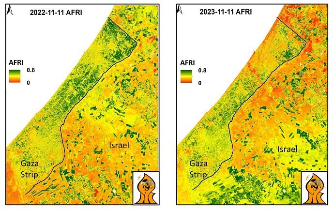
"This is an index that we developed in our laboratory, which belongs to the family of vegetation indices," explains Prof. Karnieli. "In general, the more green you see in a picture, the more vegetation there is, and the more red you see, the more exposed soil. The results of the war are clearly evident, both inside the Gaza Strip and in the envelope. In the northern Gaza Strip, we see more red areas than in the south, since this area was occupied by the State of Israel. It is no secret that IDF forces strip the vegetation for fear of IED’s, mines and tunnels. Particularly prominent is the route of the Gaza River, through which IDF forces entered the Gaza Strip and moved north. These are heavy vehicles, tanks, armored personnel carriers, and bulldozers, which crush the soil and trample the vegetation. The same is true of the envelope. Armored vehicles positioned and maneuvering in the fields have caused the destruction of those fields. In addition, farmers in the envelope are still prevented from sowing autumn crops, first wheat and later potatoes, so the soil remains exposed."
The European Space Agency's Sentintal-2 satellite photographs the entire world at a resolution of between 10 and 20 meters. Prof. Karnieli is the Chief Scientist of the Venus satellite of the Israeli and French space agencies, which photographs about 100 sites in Israel and around the world at a higher resolution of 4 meters. Unfortunately, however, most of the images Venus recently took over the envelope areas were unusable.
"The Venus satellite photographs the envelope every other day, but in many cases, clouds covered the area. The satellite does not photograph most of the Gaza Strip, because we didn't think there was any scientific interest in the area when we chose the sites. Venus is a very advanced satellite designed to enable precision agriculture and is a particularly effective tool in large agricultural areas such as the fields in the Gaza envelope. A farmer in the envelope who opens a furrow in the morning returns in the afternoon. Therefore, when the residents return home, the Israeli satellite will allow farmers to monitor the state of the crops and the pace of field rehabilitation."